SFO Bay Trail Gap
Closing a critical 3.2-mile gap in the San Francisco Bay Trail while creating opportunities for wetland restoration, flood control, and community access to natural open space in the Millbrae area.
Take Action to Support This Project
📍 Location
Extent: San Bruno Avenue (north) to Millbrae Avenue (south)
Length: 3.2 miles
Adjacent: SFO Airport, US-101, BART, Caltrain, Lions Field, Bayside Manor and Bayfront Parks
Transit: Connects to Millbrae Caltrain/BART station
🌱 Project Overview
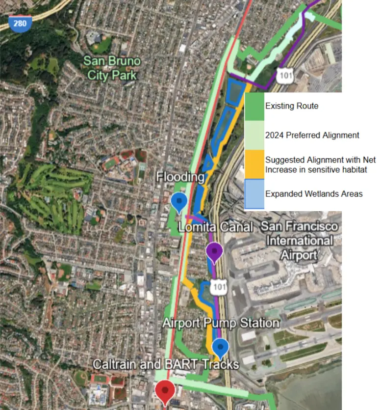
We are advocating for a more efficient and environmentally beneficial completion of the 2.5-mile San Francisco International Airport (SFO) Bay Trail gap between San Bruno Avenue and Millbrae Avenue. By revising current proposals, we can transform this project into a multi-benefit initiative that activates the 180-acre “West of Bayshore” property for habitat restoration, flood control, and public recreation.
The current "Preferred Alignment" for the trail involves significant costs (estimated at $64M) and includes four additional railroad crossings, which may negatively impact the user experience and project feasibility. Furthermore, nearby residential areas like Landing Lane suffer from chronic flooding due to insufficient drainage infrastructure and limited maintenance of the Lomita Canal.
We suggest an alternative alignment that prioritizes both active transportation and ecological health:
Integrated Wetland Restoration: Expand the existing canal system to create up to 30 acres of new wetland and upland habitat.
Sustainable Infrastructure: Utilize excavated material from wetland restoration to create earthen embankments for the trail, reducing the need for costly causeway structures while expanding wildlife corridors.
Flood Mitigation: By restoring the floodplain adjacent to the existing canal, this project can provide a synergy with the Millbrae Storm Drain Master Plan to alleviate local neighborhood flooding.
Enhanced Connectivity: Create a more direct and efficient route through the West of Bayshore open space, providing a high-quality "park-like" experience for cyclists and pedestrians.
Wildlife Viewing Zones: Expanded embankment 'bulb-outs' to facilitate birdwatching and bay views.
Public Amenities: Installation of permanent binoculars, benches, and picnic tables to encourage community engagement with the natural landscape.
🤝 Supporters & Advocates
Lead Advocate:Merrin (Millbrae Bike Park)
Project Leads:
• San Mateo County Transportation Authority (SMCTA)
• City of San Bruno
• City of Millbrae
• City of San Francisco (main land owner)
Primary Stakeholders:
• San Francisco International Airport
• SFPUC
• County of San Mateo
• Metropolitan Transportation Commission
• Caltrans, BART, Caltrain
Contact: millbraebikepark@gmail.com
💰 Funding & Status
Estimated Cost: $50 million
Current Status: Feasibility study complete for preferred alignment; funding needed for preliminary design and environmental clearance
Funding Sought From:
• State Coastal Conservancy
• Priority Conservation Area grant program
• SMCTA's Measure A & W Pedestrian and Bicycle Program
• MTC Regional Measure 3 Safe Routes to Transit & Bay Trail
🗺️ Site Location Map
Location: San Bruno Avenue to Millbrae Avenue, west of US-101 and SFO Airport
Interactive map showing the SFO Bay Trail Gap project area.
🌿 Why This is a Green Infrastructure Project
This project presents a unique opportunity to combine trail construction with environmental restoration and flood control:
- West of Bayshore Property: The trail gap overlaps a 180-acre property called "West of Bayshore" owned by the City and County of San Francisco, presenting opportunities for green infrastructure integration
- Wetland Restoration: Portions of the trail built on earthen embankments (instead of costly causeway structures) could be offset by expanding wetland areas by up to 30 acres
- Flood Control: The nearby Landing Lane neighborhood experiences flooding issues. Expanding wetlands in the canal area could improve drainage capacity while creating habitat
- Habitat Enhancement: Rather than just minimizing disturbance to sensitive habitat, this approach could maximize net wetland and upland habitat restoration
- Cost Reduction: Replacing some causeway sections with earthen embankment (using excavated material from wetland expansion) could reduce the $64M project cost while improving outcomes
💧 Drainage & Flood Control Synergy
The Millbrae Storm Drain Master Plan documents flooding issues in the Landing Lane area. The canal that drains this neighborhood runs through the project area, and maintenance is limited due to sensitive habitat considerations.
Expanding wetlands along the canal could:
- Increase drainage capacity beyond what canal maintenance alone can achieve
- Provide natural stormwater retention during peak flows
- Create additional habitat while solving infrastructure problems
- Potentially connect to SFPUC's Millbrae facility drainage improvements
The SFPUC Millbrae Campus has approximately $300M in renovation planned, which will likely include green infrastructure for stormwater management. The expanded wetlands in this trail project could complement those improvements.
🎯 Project Goals
- Close the Bay Trail Gap: Complete 3.2 miles of multiuse path connecting 13 continuous miles of regional trail
- Active Transportation: Enable bicycle commuters to access employment centers at SFO and transit connections at Millbrae station
- Community Access: Provide families and children access to natural open green space in a densely developed area
- Maximize Habitat: Explore alignments that expand wetland habitat rather than just minimize disturbance
- Improve Drainage: Address flooding in the Landing Lane neighborhood through expanded wetland capacity
- Cost Efficiency: Evaluate earthen embankment alternatives to reduce causeway costs while achieving better environmental outcomes
📋 Proposed Alignment Improvements
The current $64M preferred option follows a 1998 alignment with causeway structure construction through sensitive areas. Community advocates suggest modifications that could reduce cost while improving outcomes:
- Partial Causeway: Replace some causeway sections with earthen embankment, using excavated material from wetland expansion
- Wildlife Crossings: Include enough causeway sections between embankments to allow wildlife passage under the trail
- More Efficient Route: The "West of Bayshore" alignment could be more direct with small lengths of new trail connecting existing access roads
- Public Access: Create more of a park-like setting rather than just a fenced trail corridor
📈 Current Status & Next Steps
Completed: December 2024 feasibility study by Metropolitan Transportation Commission
Current Phase: SMCTA is seeking grant funding for environmental documentation and engineering
Needed:
- Letters of support from community members and organizations
- Advocacy with elected officials
- Identification of diversified funding streams (grants, foundations, corporate giving)
- Evaluation of green infrastructure alternatives that could reduce cost and improve outcomes
Official Contact: Patrick Gilster, Director of Planning and Fund Management, SMCTA - gilsterp@samtrans.com
📚 References & Reports
- Bay Trail SFO Gap Study Final Plan (December 2024) - $64M preferred option
- 1998 SFO Bay Trail Alignment Plan - Original $8-10M proposal
- Millbrae Storm Drain Master Plan - Documents flooding issues
- SAN FRANCISCO GARTER SNAKE RECOVERY ACTION PLAN 2019–2029 - includes drainage project canal maintenance
- 2024-02 SFO Construction Projects Overview - Includes a project to replace electrical lines on the West of Bayshore site
- SFO Landing Lane Fact Sheet - Airport's drainage responsibilities
- RFP for the drainage project - Includes some wetland expansion, likely to compensate for canal clearing. (not in the project list).
📚 Case Studies
Examples of similar Bay Trail sections and park amenities that could inform the SFO Gap Trail design: